
Macroseismic intensity data and effects of significant earthquakes in Colombia based on historical seismicity studies
DOI:
https://doi.org/10.32685/0120-1425/bol.geol.48.2.2021.638Keywords:
earthquake, intensity scale, EMS-98, information system, seismological parameters, seismic hazard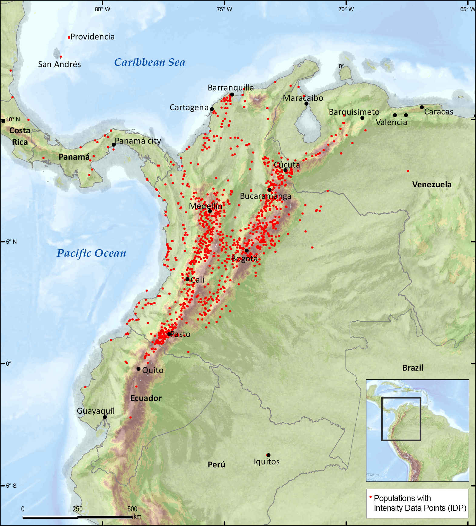
License
Copyright (c) 2022 Servicio Geológico Colombiano

This work is licensed under a Creative Commons Attribution 4.0 International License.
Downloads
Additional Files
How to Cite
Issue
Section
Published
Abstract
This article presents data on the macroseismic intensities and the effects of earthquakes that have caused significant damage in Colombia, generated in the historical seismicity reports that are prepared for the seismic hazard and risk projects of the Servicio Geológico Colombiano (SGC). These data are the result of research based on the collection, organization and analysis of information related to the effects of earthquakes, according to the methodology of the European Macroseismic Scale of 1998 (EMS-98), which manages descriptions and degrees of intensity according to the effects on people, objects, buildings and nature.
These data are available to the public through the Historical Seismicity Information System of Colombia (Sistema de Información de Seismicidad Histórica de Colombia [SISHC]), which is an application on the web with free access. There are more than 5000 intensity data points and approximately 4000 reports associated with the effects of historical earthquakes, which can be used in a variety of ways, such as academic, scientific and institutional studies, historical research, and seismic hazard and risk management evaluations.
References
Ceresis. (1985). Mapa de intensidades máximas en América del Sur. (Vol. 12). Serie SISRA.
Di Giacomo, D., & Sarabia Gómez, A. M. (2021). Use of macroseismic and instrumental data to reassess earthquake locations: Examples from pre-digital earthquakes in Colombia. Journal of South American Earth Sciences, 111, 103467. https://doi.org/10.1016/J.JSAMES.2021.103467
Espinosa Baquero, A. (2003). Historia Sísmica de Colombia, 1550-1830. Academia Colombiana de Ciencias Exactas, Físicas y Naturales and Universidad del Quindío.
Espinosa, A. (2012). Enciclopedia de Desastres Naturales Históricos en Colombia. Academia Colombiana de Ciencias Exactas, Físicas y Naturales and Universidad del Quindío.
Estrada Uribe, G., & Ramírez, J. (1977). Mapa de riesgo sísmico. Instituto Geofísico Universidad Javeriana. Bogotá. Citado en: Asociación Colombiana de Ingeniería Sísmica (AIS). (1996). Estudio General de Amenaza Sísmica de Colombia. Asociación Colombiana de Ingeniería Sísmica, Universidad de los Andes, Ingeominas. Bogotá.
Gisler, M., Fäh, D., & Schibler, R. (2003). Two significant earthquakes in the Rhine valley at the end of the 18th century: The events of December 6, 1795 and april 20, 1796. Eclogae Geologicae Helvetiae, 96, 357-366. https://doi.org/10.1007/s00015-003-1095-0
Gómez Capera, A., Stucchi, M., Rodríguez, L., Arcila, M., Bufaliza, M., Choy, J., Minaya, E., Leyton, L., Pirchiner, M., Rendón, H., Sarabia, A., Tavera, H., & Yepes, H. (2020). Catálogo de terremotos de América del Sur homogéneo en Mw para el periodo pre-1964. GEOS, 40(1). https://geos.cicese.mx/index.php/geos/article/view/58
Grünthal, G. (2009). European macroseismic scale EMS–98. Notes of the European Center of Geodynamics and Seismology, (vol. 15). 1, 100.
Ramírez, J. E. (1975). Historia de los terremotos en Colombia. Instituto Geográfico Agustín Codazzi.
Salcedo Hurtado, E. de J., & Gómez Capera, A. A. (1998). Sismicidad histórica y reciente base de datos. Ingeominas.
Salcedo Hurtado, E. de J., & Gómez Capera, A. G. (2000). Sismotectónica del territorio colombiano. Atlas macrosísmico de Colombia. Ingeominas.
Sarabia Gómez, A. M. (2015). Mapa de intensidades máximas observadas para Colombia. Servicio Geológico Colombiano. https://recordcenter.sgc.gov.co/B6/21001100024689/documento/pdf/2105246891101000.pdf
Sarabia Gómez, A. M. (2016). Relación de atenuación de la intensidad sísmica para sismos corticales en Colombia. Método Bakun & Wentworth. Servicio Geológico Colombiano.
Servicio Geológico Colombiano (SGC). (2016). Sistema de información de Sismicidad Histórica de Colombia. http://sish.sgc.gov.co/visor/
Servicio Geológico Colombiano. (2022). Motor de Integración de información geocientífica (MIIG). https://miig.sgc.gov.co/


