
Potential and prospects for hydrogeological exploration according to lithostructural criteria in Antioquia department, Colombia
DOI:
https://doi.org/10.32685/0120-1425/bol.geol.49.2.2022.627Keywords:
groundwater, secondary permeability, hydrogeology in Antioquia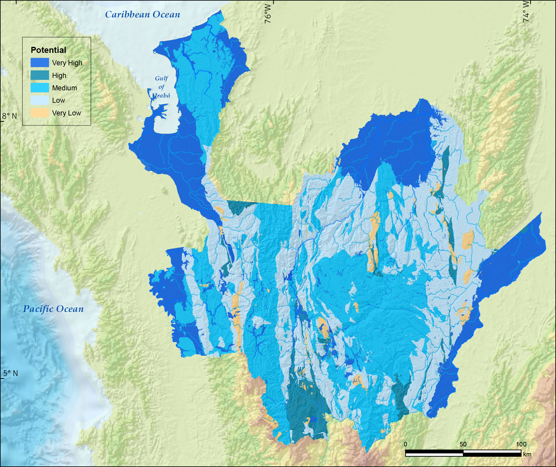
License
Copyright (c) 2022 Servicio Geológico Colombiano

This work is licensed under a Creative Commons Attribution 4.0 International License.
Downloads
Additional Files
How to Cite
Issue
Section
Published
Abstract
In the department of Antioquia, in addition to the geological units with primary porosity, the tecto-structural characteristics of the hard rocks confer permeability properties to the metamorphic and igneous units that allow the flow and storage of groundwater. This work aims to synthesize useful information to identify potential areas to conduct new hydrogeological explorations in Antioquia.
The official geological map at 1:100 000 scale, adjusted to the geological map of Antioquia 1:400 000 scale, provided the basic input to separate the different types of rock and their structural affectations to identify permeability characteristics that were scored ranging from very low and very high. The concept of determining hydrogeological potential based on geological criteria is centered on the idea that the nature and distribution of aquifers and aquitards in a geological system are controlled by the lithology, stratigraphy, and structures of the deposits and geological formations.
The results of this study showed that the Medellin Dunite, slope deposits, Guineales Formation, Tertiary alluvial, Cerrito Formation, Sincelejo Group, Corpa Formation, terraces and recent alluviums, and Mesa Formation have very high aquifer potential (23.4% of the departmental area); 5% of the surface of the department has rocks with high aquifer potential; 35% has rocks with moderate aquifer potential; and the remaining 37% of the department has a lower aquifer potential.
Based on these findings, in terms of the groundwater potential in Antioquia, the area includes geological units with porosity and primary and secondary permeability. Thus, groundwater exploration in this department is urgently needed to provide hydrogeological knowledge to assist in the search for complementary sources of water supply for the population.
References
Anand, R. R., & Paine, M. (2002). Regolith geology of the Yilgarn Craton, Western Australia: Implications for exploration. Australian Journal of Earth Sciences, 49(1), 3-162. https://doi.org/10.1046/j.1440-0952.2002.00912.x
Anbarasu, S., Brindha, K., & Elango, L. (2020). Multi-influencing factor method for delineation of groundwater potential zones using remote sensing and GIS techniques in the western part of Perambalur district, southern India. Earth Science Informatics, 13, 317-332. https://doi.org/10.1007/s12145-019-00426-8
Área Metropolitana del Valle de Aburrá (AMVA), & Consorcio Microzonificación (Solingral S.A., Integral S.A., Inteinsa, Universidad EAFIT, Universidad Nacional de Colombia, sede Medellín). (2007). Microzonificación sísmica detallada de los municipios de Barbosa, Girardota, Copacabana, Sabaneta, La Estrella, Caldas y Envigado. https://repositorio.gestiondelriesgo.gov.co/handle/20.500.11762/19862
Arias, P., Ortega, G., Villegas, L., & Martínez, A. (2021). Colombian climatology in CMIP5/CMIP6 models: Persistent biases and improvements. Revista Facultad de Ingeniería, Universidad de Antioquia, 100, 75-96.
Arnous, M. O. (2016). Groundwater potentiality mapping of hard-rock terrain in arid regions using geospatial modelling: Example from Wadi Feiran basin, South Sinai, Egypt. Hydrogeology Journal, 24, 1375-1392. https://doi.org/10.1007/s10040-016-1417-8
Bermúdez, J. G., Arango, M. I., Rodríguez, G., Zapata, G., & Ramírez, C. (2012). Cartografía geológica de las planchas 72 Pueblo Nuevo y 82 Montelíbano, departamento de Córdoba. Escala 1:100 000. Servicio Geológico Colombiano. http://recordcenter.sgc.gov.co/B13/23008010024552/mapa/pdf/2105245521300004.pdf
Betancur, T., & Martínez, C. (2021). Acople de la cartografía geológica disponible para Antioquia a escala 1:100.000, base para la exploración hidrogeológica. In Memorias XVIII Congreso Colombiano de Geología. https://sociedadcolombianadegeologia.org/acople-de-la-cartografia-geologica-disponible-para-antioquia-a-escala-1100-000-base-para-la-exploracion-hidrogeologica/
Betancur, T., Duque, C., Martínez, C., García, D., Villegas, P., & Paredes, V. (2020). Delimitación de potenciales zonas de recarga. Caso de estudio: acuífero multicapa del eje bananero del Urabá antioqueño. Revista Politécnica, 16(32), 41-55.
Briški, M., Stroj, A., Kosović, I., & Borović, S. (2020). Characterization of aquifers in metamorphic rocks by combined use of electrical resistivity tomography and monitoring of spring hydrodynamics. Geosciences, 10(4), 137. https://doi.org/10.3390/geosciences10040137
Brkió, Z., Kuhata, M., Larva, O., & Gottetein, S. (2019). Groundwater and connected ecosystems: An overview of groundwater body status assessment in Croatia. Environmental Sciences Europe, 31, art. 75.
Calle, B., & González, H. (1980). Geología y geoquímica de la plancha 166 Jericó. Escala 1:100 000. Servicio Geológico Colombiano. http://recordcenter.sgc.gov.co/B4/13010010024374/mapa/pdf/0101243741300002.pdf
Calle, B., & González, H. (1982). Geología y geoquímica de la plancha 186 Riosucio. Escala 1:100 000. Producto. Versión 1982 estandarizada en 2009. Servicio Geológico Colombiano. http://recordcenter.sgc.gov.co/B4/13010010024379/mapa/pdf/0101243791300002.pdf
Cilona, A., Aydin, A., Likerman, J., Parker, B., & Cherry, J. (2016). Structural and statistical characterization of joints and multi-scale faults in an alternating sandstone and shale turbidite sequence at the Santa Susana Field Laboratory: Implications for their effects on groundwater flow and contaminant transport. Journal of Structural Geology, 85, 95- 114. https://doi.org/10.1016/j.jsg.2016.02.003
Corporación Autónoma Regional del Centro de Antioquia (Corantioquia), & Universidad de Antioquia (2014). Plan de manejo ambiental del sistema acuífero del Bajo Cauca antioqueño, segunda etapa. https://www.corantioquia.gov.co/ciadoc/fauna/GA_CV_964_2013.pdf
Custodio, E., & Llamas, M. R. (1996). Hidrología subterránea. Ediciones Omega.
Dávila, C., Gil, C., Ibáñez, R., López, C., Orozco, L., Patiño, A., Pinilla, A., Quiñones, C., Román, J., Ramos, K., & Savanier, D. (2018a). Anexo J. Mapa geológico de la plancha 92 Tierradentro. Escala 1:100 000. Servicio Geológico Colombiano. https://recordcenter.sgc.gov.co/B23/678_19MemExPl92Tierradentro/Mapa/Pdf/AnexoJ_MapaGeolPl92.pdf
Dávila, C., Gil, C., Ibáñez, R., López, C., Pinilla, A. Quiñones C., Ramos, K., & Román J. (2018b). Anexo J. Mapa geológico de la plancha 91 Belencito. Escala 1:100 000. Servicio Geológico Colombiano. Bogotá. https://recordcenter.sgc.gov.co/B23/677_19MemExPl91Belencito/Mapa/Pdf/AnexoJMapaGeolPl91.pdf
De Vries, J. J., & Simmers, I. (2002). Groundwater recharge: An overview of processes and challenges. Hydrogeology Journal, 10, 5-17. https://doi.org/10.1007/s10040-001-0171-7
Departamento Nacional de Planeación (DNP). (2021). Agua limpia y saneamiento. In Objetivos de Desarrollo Sostenible. https://ods.dnp.gov.co/es/objetivos/agua-limpia-y-saneamiento
Dewandel, B., Lachassagne, P., Wyns, R., Marechal, J. C., & Krishnamurthy, N. S. (2006). A generalized 3-D geologicaland hydrogeological conceptual model of granite aquifers controlled by singleor multiphase weathering. Journal of Hydrology, 330(1-2), 260-284. https://doi.org/10.1016/j.jhydrol.2006.03.026
Faulkner, D. R., Jackson, C. A. L., Lunn, R. J., Schlische, R. W., Shipton, Z. K., Wibberly, C. A. J., & Withjack, M. D. (2010). A review of recent developments concerning the structure, mechanics and fluid flow properties of fault zones. Journal of Structural Geology, 32(11), 1557-1575. https://doi.org/10.1016/j.jsg.2010.06.009
Feininger, T., Barrero, D., Castro, N., Ramírez, O., Lozano, H., & Vesga, J. (1970). Mapa geológico de Colombia, oriente de Antioquia. Cuadrángulo I-9 y parte de los cuadrángulos H-9, H-10, I-10, J-9 y J-10. Plancha 117 Amalfi, plancha 132 Yolombó, plancha 148 San Carlos, plancha 168 Argelia (Aquitania), plancha 188 La Dorada. Escala 1:100 000. Producto. Versión año 1970 estandarizada en 2010. Servicio Geológico Colombiano. Bogotá. http://recordcenter.sgc.gov.co/B4/13010010024246/mapa/pdf/0101242461300010.pdf
Fiume, B., João Fernandes, A., Bolognini Barbosa, M., Hirata, R., & Bertolo, R. (2020). Integrated application of geophysical loggings and fracture survey on rock exposures for identifying transmissive fractures in crystalline aquifer: Case study in the city of São Paulo. Brazilian Journal of Geology, 50(1), 1-17. https://doi.org/10.1590/2317-4889202020190034
Fonseca, H. A., Fuquen, J. A., Mesa, L. D., Talero, C. A., Pérez, O. G., Porras, J. J., Gavidia, O. A., Pacheco, S. M., Pérez, J. F., Amaya, E., García, Y., & Enrique, F. (2011). Cartografía geológica de la plancha 133 Puerto Berrío. Escala 1:100 000. Contrato 041/2010. Servicio Geológico Colombiano. http://recordcenter.sgc.gov.co/B13/23008010024508/mapa/pdf/2105245081300001.pdf
Fonseca, H. A., Fuquen, J. A., Mesa, L. D., Talero, C. A., Pérez, O. G., Porras, J. J., Gavidia, O. A., Pacheco, S. M., Amaya, E., García, Y., & Enrique, F. (2012). Cartografía geológica de la plancha 108 Puerto Wilches. Escala 1:100 000. Contrato n.° 041/2010. Servicio Geológico Colombiano. http://recordcenter.sgc.gov.co/B13/23008010024507/mapa/pdf/2105245071300001.pdf
Freeze, R. A., & Cherry, J. A. (1979). Groundwater. Prentice Hall.
Geotec Ltda. (2003). Geología de los cinturones Sinú – San Jacinto – Planchas 50 Puerto Escondido, 51 Lorica, 59 Mulatos, 60 Canalete, 61 Montería, 69 Necoclí, 70 San Pedro de Urabá, 71 Planeta Rica, 79 Turbo, 80 Tierralta. Escala 1:100 000. Servicio Geológico Colombiano. Bogotá. http://recordcenter.sgc.gov.co/B4/13010010020013/mapa/pdf/0101200131300008.pdf
Gobernación de Antioquia. (2018). Anuario estadístico de Antioquia. http://www.antioquiadatos.gov.co/index.php/anuario-estadistico-2018
Gómez, J. F., Albarracín, H., Sepúlveda, J., Sepúlveda L., Rodríguez, G., Salazar, G., Zapata, G., & Nivia, A. (2011). Mapa geológico de la plancha 131 Santa Rosa de Osos. Escala 1:100 000. Servicio Geológico Colombiano. Bogotá. http://recordcenter.sgc.gov.co/B13/23008010024403/mapa/pdf/2105244031300001.pdf
Gómez, L. A., Fuquen, J. A., Quintero, C., Patiño, A., Beltrán, A., López, C., Lancheros, J. A., Renzoni, G., & Manrique, M. (2009). Cartografía geológica y muestreo geoquímico escala 1:100 000 de la plancha 149 – Puerto Nare (Puerto Serviez). Contrato 398 de 2007. Producto. Versión 2009. Servicio Geológico Colombiano. Bogotá. http://recordcenter.sgc.gov.co/B12/23008010024352/mapa/pdf/2105243521300002.pdf
Gómez, L. A., Patiño, A., Renzoni, G., Beltrán, A., Quintero, C., & Manrique, M. (2008). Cartografía geológica y muestreo geoquímico escala 1:100.000 de la plancha 119 – Barrancabermeja Valle Medio del Magdalena. Contrato 398. Producto. Servicio Geológico Colombiano. http://recordcenter.sgc.gov.co/B12/23008010024350/mapa/pdf/2105243501300002.pdf
González, H. (1980). Geología de la plancha 167 Sonsón y Plancha 187 Salamina. Escala 1:100 000. Versión 1980. Versión digital 2009. Servicio Geológico Colombiano. Servicio Geológico Colombiano. Bogotá. http://recordcenter.sgc.gov.co/B18/23008010028501/mapa/pdf/2105285011300005.pdf
González, H. (1992). Mapa geológico de Colombia, plancha 106 Liberia. Escala 1:100 000. Producto. Versión 1992 estandarizado en 2009. Servicio Geológico Colombiano. http://recordcenter.sgc.gov.co/B4/13010010024236/mapa/pdf/0101242361300002.pdf
González, H. (2001). Mapa geológico del departamento de Antioquia. Escala1:400 000. Ingeominas. https://miig.sgc.gov.co/Paginas/Resultados.aspx?k=130100101040020038000000000
González, H., & Salazar, G. (2002). Geología de la Plancha 145 Urrao. Escala 1:100 000. Servicio Geológico Colombiano. http://recordcenter.sgc.gov.co/B4/13010010024480/mapa/pdf/0101244801300004.pdf
González, H., Cossio, U., Maya, M., Vásquez, E., & Holguín, M. (1996). Mapa geológico del departamento de Antioquia. Escala 1:400 000. Mapa. Versión 1996. Ingeominas. https://recordcenter.sgc.gov.co/B4/13010040020038/mapa/pdf/0101200381300002.pdf
González, H., Maya, M., Cardona, O. D., Arias, E., N., Castañeda, D. M., Ruiz, C. F., Montero, J. E., Camacho, J. A., Palacio, A. F., Gómez, J. P., Vélez, W., & Álzate, G. A. (2015b). Mapa geológico de la plancha 94 El Bagre. Escala 1:100 000. Servicio Geológico Colombiano. http://recordcenter.sgc.gov.co/B18/23008010028502/mapa/pdf/2105285021300007.pdf
González, H., Maya, M., García J., Gómez, J. P., Palacio A. F., Ruiz, C. F., Camacho, J., Montero, J. E., Grimaldo, J., & Álzate, G. A. (2015a). Mapa geológico de la plancha 84 Los Canelos. Escala 1:100 000. Servicio Geológico Colombiano. http://recordcenter.sgc.gov.co/B18/23008010028501/mapa/pdf/2105285011300005.pdf
González, H., Maya, M., García, J., Gómez, J. P., Palacio, A. F., Ruiz, C. F., Montero, J. E., Camacho, J., Grimaldo, J., Vélez, W., & Álzate, G. A. (2015c). Mapa geológico de la plancha 95 Buenavista. Escala 1:100 000. Servicio Geológico Colombiano. http://recordcenter.sgc.gov.co/B18/23008010028503/mapa/pdf/2105285031300005.pdf
González, H., Maya, M., Tabares, L. F., Montoya, A., Palacio, A. F., Sánchez, C., Barajas, A., & Vélez, W. (2015e). Elaboración de la cartografía geológica de un conjunto de planchas. Escala 1:100 000, ubicadas en cuatro bloques del territorio nacional, identificados por el Servicio Geológico Colombiano. Plancha 118 San Francisco. Versión 2015. Servicio Geológico Colombiano. http://recordcenter.sgc.gov.co/B19/23008010028505/mapa/pdf/2105285051300007.pdf
González, H., Maya, M., Tabares, L., Montoya, A., Arias, E. N., Osorio, J. H., Pérez, O., Buriticá, L. F., Vélez, W., & Álzate, G. A. (2015d). Mapa geológico de la plancha 107 Cerro Azul. Escala 1:100 000. Servicio Geológico Colombiano. http://recordcenter.sgc.gov.co/B19/23008010028504/mapa/pdf/2105285041300005.pdf
Gotta Ingeniería S. A. S., & Corporación Autónoma Regional del Centro de Antioquia (Corantioquia). (2018). Formulación del plan de manejo ambiental del Sistema Acuífero del Magdalena Medio Antioqueño. https://www.corantioquia.gov.co/ciadoc/AGUA/AIRNR_110_CNT1706_46_2017_00FASE%20APRESTAMIENTO.pdf
Hall, R., Álvarez, J., Rico, H., & Vásquez, H. (1970). Mapa geológico de Colombia. Cuadrángulo H-7 Ituango: plancha 104 Ituango - plancha 115 Toledo. Cuadrángulo H-8 Yarumal: plancha 105 Valdivia - plancha 116 Yarumal. Escala 1:100 000. Producto. Versión 1970 y 1975 estandarizado y digitalizado en 2010. Servicio Geológico Colombiano. http://recordcenter.sgc.gov.co/B4/13010010024235/mapa/pdf/0101242351300002.pdf
Harlow, J., & Hagedorn, B. (2018). SWB modeling of groundwater recharge on Catalina Island, California, during a Period of Severe Drought. Water, 11(1), art. 58. https://doi.org/10.3390/w11010058
Henriksen, H., & Braathen, A. (2006). Effects of fracture lineaments and in-situ rock stresses on groundwater flow in hard rocks: A case study from Sunnfjord, western Norway. Hydrogeology Journal, 14, 444-461. https://doi.org/10.1007/s10040-005-0444-7
Hoque, M., Burgess, W. G., & Ahmed, K. M. (2017). Integration of aquifer geology, groundwater flow and arsenic distribution in deltaic aquifers - A unifying concept. Hydrological Processes, 31(11), 2095-2109. https://doi.org/10.1002/hyp.11181
Instituto de Hidrología, Meteorología y Estudios Ambientales (Ideam). (2019). Estudio nacional del agua, 2018. http://documentacion.ideam.gov.co/openbiblio/bvirtual/023858/ENA_2018.pdf
Instituto Geográfico Agustín Codazzi (IGAC) e Instituto de Investigaciones en Geociencias, Minería y Química (Ingeominas). (2005). Investigación Integral del Andén Pacífico Colombiano - Cartografía Geología, Geomorfología, Suelos y Amenazas de las planchas 58, 59, 68, 69, 79, 79BIS, 89, 89BIS, 90, 100, 101, 102, 112, 112BIS, 113, 127, 128, 143, 144, 163, 164, 165, 183, 184, 185, 202, 203, 204, 221, 222, 240, 241, 259, 260, 278, 279, 298, 299, 318, 319, 320, 339, 340, 341, 361, 361BIS, 362, 363, 383, 384, 385, 386, 407, 408, 409, 427, 427BIS, 428, 447 y 447BIS. Escala 1:100 000. Servicio Geológico Colombiano. http://recordcenter.sgc.gov.co/B4/13010010024479/mapa/pdf/0101244791300009.pdf
Kalhor, K., Ghasemizadeh, R., Rajic, L., & Alshawabkeh, A. (2019). Assessment of groundwater quality and remediation in karst aquifers: A review. Groundwater for Sustainable Development, 8, 104-121. https://doi.org/10.1016/j.gsd.2018.10.004
Karro, E., & Lahermo, P. (1999). Occurrence and chemical characteristics of groundwater in Precambrian bedrock in Finland. Geological Survey of Finland, 27, 85-96.
Kassem, B. T., Álvarez, A. J., & Arango C. J. (1979). Mapa geológico del departamento de Antioquia. Escala 1:500 000. Mapa. Versión 1979. Ingeominas. https://recordcenter.sgc.gov.co/B4/13010040020038/mapa/pdf/0101200381300003.pdf
La Felice, S., Montanari, D., Battaglia, S., Bertini, G., & Gianelli, G. (2014). Fracture permeability and water–rock interaction in a shallow volcanic groundwater reservoir and the concern of its interaction with the deep geothermal reservoir of Mt. Amiata, Italy. Journal of Volcanology and Geothermal Research, 284, 95-105. https://doi.org/10.1016/j.jvolgeores.2014.07.017
Lachassagne, P., Dewandel, B., & Wyns, R. (2021). Review: Hydrogeology of weathered crystalline/hard-rock aquifers— guidelines for the operational survey, and management of their groundwater resources. Hydrogeology Journal, 29, 2561-2594. https://doi.org/10.1007/s10040-021-02339-7
Londoño, A. C., & González, H. (2002). Geología de la plancha 129 Cañasgordas. Escala 1:100 000. Servicio Geológico Colombiano. http://recordcenter.sgc.gov.co/B4/13010010024480/mapa/pdf/0101244801300002.pdf
Mejía, M., Álvarez, E., González, H., & Grosse, E. (1983). Geología de la plancha 130. Santa Fe de Antioquia. Escala 1:100 000. Servicio Geológico Colombiano. http://recordcenter.sgc.gov.co/B4/13010010001950/mapa/pdf/0101019501300002.pdf
Mejía, M., Álvarez, E., González, H., & Grosse, E. (1983). Geología de la plancha 146. Medellín occidental. Escala 1:100 000. Servicio Geológico Colombiano. Bogotá. https://recordcenter.sgc.gov.co/B4/13010010001950/mapa/pdf/0101019501300006.pdf
Mejía, O. (2006). Algunos elementos sobre el recurso hídrico en la jurisdicción de Corantioquia. Corantioquia. https://www.corantioquia.gov.co/ciadoc/AGUA/AIRNR_AGUA_473CD_2005_V1.pdf
Mussa, K. R., Mjemah, I. C., & Machunda, R. L. (2020). Open-source software application for hydrogeological delineation of potential groundwater recharge zones in the Singida semi-arid, fractured aquifer, Central Tanzania. Hydrology, 7(2), art. 28. https://doi.org/10.3390/hydrology7020028
Nikić, Z., Pušić, M., Papić, P., & Marić, N. (2020). Hydrodynamic model of hydrogeologic fracture system in Gruda ultramafic rocks, western Serbia. Journal of Hydrology, 580, 124268. https://doi.org/10.1016/j.jhydrol.2019.124268
Norton, D., & Knapp, K. (1997). Transport phenomena in hydrothermal systems: The nature of porosity. American Journal of Science, 277(8), 913-936. https://doi.org/10.2475/ajs.277.8.913
Ossa, J., Campillo, A. K., Omar, C., & Betancur, T. (2021). Representación espacial de zonas de recarga del agua subterránea a partir de mapas isotópicos de precipitación. Caso de estudio: Valle de Aburrá, Colombia. Boletín Geológico y Minero de España, 132(1-2), 65-75. https://doi.org/10.21701/bolgeomin.132.1-2.007
Patiño-Rojas, S. M., Jaramillo, M., Espinosa-Espinosa, C. A., & Arias-López, M. F. (2021). Preferential groundwater flow directions in a pseudokarst system in Colombia, South America. Journal of South American Earth Sciences, 112, Part. 1. https://doi.org/10.1016/j.jsames.2021.103572
Poveda, G. (2007). El clima de Antioquia. In M. Hermelin (ed.) Geografía de Antioquia: Geografía histórica, física, humana y económica. Universidad EAFIT. https://repository.eafit.edu.co/handle/10784/17431?show=full
Poveda, G., Álvarez, D. M., & Rueda, O. A. (2010). Hydro-climatic variability over the Andes of Colombia associated with ENSO: A review of climatic processes and their impact on one of the Earth’s most important biodiversity hotspots. Climate Dynamics, 36, 2233-2249. https://doi.org/10.1007/s00382-010-0931-y
Qian, X., Wang, Y., Zhang, Y., Senebouttalath, V., Zhang, A., & He, H. (2019). Petrogenesis of Permian–Triassic felsic igneous rocks along the Truong Son zone in northern Laos and their Paleotethyan assembly. Lithos, 328-329, 101-114. https://doi.org/10.1016/j.lithos.2019.01.006
Ren, X. W., & Santamarina, J. C. (2018). The hydraulic conductivity of sediments: A pore size perspective. Engineering Geology, 233, 48-54. https://doi.org/10.1016/j.enggeo.2017.11.022
Restrepo, J. J., & Toussaint, J. F. (2020). Tectonostratigraphic terranes in Colombia: An update. First part: Continental terranes. In J. Gómez, & D. Mateus-Zabala (eds.), The geology of Colombia. Volume 1. Proterozoic – Paleozoic (pp. 37-63). Servicio Geológico Colombiano. https://doi.org/10.32685/pub.esp.35.2019.03
Rodríguez, E. E., & Ulloa, C. Rodríguez, G., Zapata, G., Gómez, J. F. (2013). E. (1994). Geología de la plancha 169 Puerto Boyacá. Escala 1:100 000. Servicio Geológico Colombiano. http://recordcenter.sgc.gov.co/B4/13010010012149/mapa/pdf/0101121491300002.pdf
Rodríguez, G., Sierra, M. I., Zapata, G., Correa, T., Peláez, J., & Nivia, Á. (2010). Geología de las planchas 58 Sapzurro (Capurganá), 68 Acandí y 79 Bis Unguía (Cerro Tagarí). Escala 1:100 000. Servicio Geológico Colombiano. http://recordcenter.sgc.gov.co/B12/23008010024303/mapa/pdf/2105243031300025.pdf
Rodríguez, G., Zapata, G., & Gómez, J. F. (2013). Geología de la plancha 114 Dabeiba. Escala 1:100 000. Servicio Geológico Colombiano. http://recordcenter.sgc.gov.co/B14/23008010024725/mapa/pdf/2105247251300001.pdf
Rodríguez, G., Zapata, G., González, H., & Cossio, U. (2005). Geología de la plancha 147, Medellín Oriental. Departamento de Antioquia. Escala 1:100 000. Servicio Geológico Colombiano. http://recordcenter.sgc.gov.co/B12/23008010002745/mapa/pdf/2105027451300002.pdf
Rukavičková, L., Holeček, J., Holečková, P., Najser, J., Gvoždík, L., & Pačes, T. (2021). Comparison of hydraulic conductivity of rock matrix and fractured blocks of granitic rocks. International Journal of Rock Mechanics and Mining Sciences, 144, 104743. https://doi.org/10.1016/j.ijrmms.2021.104743
Scesi, L., & Gattinoni, P. (2007). Roughness control on hydraulic conductivity in fractured rocks. Hydrogeology Journal, 15(2), 201-211. https://doi.org/10.1007/s10040-006-0076-6
SHI S. A. S., & Corporación Autónoma Regional del Centro de Antioquia (Corantioquia). (2015). Diagnóstico para la formulación del plan de manejo ambiental del Sistema Acuífero del Occidente Antioqueño en la Territorial Hevéxicos de Corantioquia - Contrato 14-09-241. https://www.corantioquia.gov.co/ciadoc/AGUA/AIRNR_CN_1608_77_2016_PMAA_OCCIDENTE_APRESTAMIENTO.pdf
SHI S. A. S., & Corporación Autónoma Regional del Centro de Antioquia (Corantioquia). (2014). Evaluación hidrogeológica en los municipios de La Pintada y Valparaíso jurisdicción de la Dirección Territorial Cartama de Corantioquia. https://www.corantioquia.gov.co/ciadoc/AGUA/GA_CN_9909_2013.pdf
Srinivasa Rao, Y., Reddy, T. V. K., & Nayudu, P. T. (2000). Groundwater targeting in a hard-rock terrain using fracture-pattern modeling, Niva River basin, Andra Pradesh, India. Hydrogeology Journal, 8, 494-502. https://doi.org/10.1007/s100400000090
Universidad de Antioquia, & Área Metropolitana del Valle de Aburrá (AMVA). Plan de manejo ambiental de acuíferos del Valle de Aburrá. https://www.metropol.gov.co/ambiental/recurso-hidrico/Paginas/PMAA.aspx
Universidad de Antioquia, & Corporación para el Desarrollo Sostenible del Urabá (Corpourabá). (2016). Plan de manejo ambiental de acuífero Sistema Hidrogeológico Golfo de Urabá. http://repositorio.corpouraba.gov.co:8082/xmlui/handle/123456789/87
Universidad de Antioquia, & Corporación para el Desarrollo Sostenible del Urabá (Corpourabá). (2014). Convenio Interadministrativo de Cooperación 136 de 2013 Universidad de Antioquia-Corporación para el Desarrollo Sostenible del Urabá.
Universidad de Antioquia, & Integral. (2002). Estudio de zonas de recarga y acuíferos del Valle de Aburrá. https://www.corantioquia.gov.co/ciadoc/agua/airnr_cn_2420_2000.pdf
Vargas, O., Campillo, A., García, M., & Rodríguez, O. (2013). Las aguas subterráneas en Colombia, una visión integral. Instituto de Hidrología, Meteorología y Estudios Ambientales (Ideam).
Verma, O., Khosla, A., Goin, F. J., & Kaur J. (2016). Historical biogeography of the Late Cretaceous vertebrates of India: Comparison of geophysical and paleontological data. New Mexico Museum of Natural History and Science Bulletin, 71, 317-330.
Zapata, G., & Cossio, U. (2001). Mapa fotogeológico con control de campo de la plancha 93 Cáceres. Escala 1:100 000. Servicio Geológico Colombiano. Bogotá. http://recordcenter.sgc.gov.co/B4/13010010002309/mapa/pdf/0101023091300002.pdf
Zapata, G., Bermúdez, J. G., Rodríguez, G., & Arango, M.I. (2013). Cartografía geológica de la plancha 83 Nechí - Departamento de Antioquia. Escala 1:100 000. Servicio Geológico Colombiano. http://recordcenter.sgc.gov.co/B14/23008010024595/mapa/pdf/2105245951300001.pdf


