Recognition of a Propylitic–Skarn Hydrothermal System through Remote Sensing and Geochemistry for Mineral Prospectivity in La Salina, Casanare, Colombia
DOI:
https://doi.org/10.32685/0120-1425/bol.geol.53.1.2026.761Keywords:
: Remote sensing; Hydrothermal alteration; Google Earth Engine; Skarn; Geochemical validation: MTMF/SAM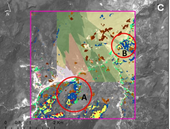
License
Copyright (c) 2026 Servicio Geológico Colombiano

This work is licensed under a Creative Commons Attribution 4.0 International License.
Downloads
How to Cite
Issue
Section
Published
Abstract
This study aimed to delineate hydrothermal alteration zones associated with mineral potential in the municipality of La Salina (Casanare, Colombia) through the integration of ASTER imagery, processing in Google Earth Engine (GEE), advanced spectral analysis, and geochemical validation. ASTER Level-1T images were processed using multitemporal composites, alteration spectral indices, land surface temperature (LST) estimation, and statistical normalization. Subsequently, the Spectral Angle Mapper (SAM) and Mixture Tuned Matched Filtering (MTMF) algorithms were applied using spectral signatures from the USGS library, and the results were integrated with geochemical analyses obtained by portable X-ray fluorescence (XRF) and a multicriteria weighting model to generate a mineral prospectivity map. The results identified a well-defined hydrothermal zonation characterized by advanced argillic alteration in the northwestern sector and propylitic alteration toward the northeast, with a high spatial correspondence among spectral responses, geochemical anomalies of tin (Sn), antimony (Sb), silver (Ag), and zinc (Zn), structural controls, and the presence of gabbroic bodies. The integration of spectral, thermal, geochemical, and geological information provides evidence for the superposition of a regional propylitic halo with skarn-type metasomatic events, allowing the delineation of priority exploration targets. The proposed methodology constitutes a reproducible and relatively low-cost procedure for the early-stage prospecting of hydrothermal systems in volcano-sedimentary environments and reinforces the integrated use of remote sensing and geochemistry in mineral exploration.
References
Abbas, A., y Tangestani, M. (2022). ASTER and Sentinel-2 integration for hydrothermal alteration mapping using MTMF and SFF. Remote Sensing of Environment, 270, Article 112853. https://doi.org/10.1016/j.rse.2021.112853
Abdolmaleki, M., Rasmussen, T.M., Pal, M.K. (2020). Exploration of IOCG mineralizations using integration of space-borne remote sensing data with airborne geophysical data. The International Archives of the Photogrammetry, Remote Sensing and Spatial Infor-mation Sciences, XLIII-B3-2020, 9–16
Al-Falahi, M. A., Pour, A. B., Park, Y. (2023). Advanced spectral indices and MTMF for gold-related alteration mapping in tropical regions. Ore Geology Reviews, 155, 105404. https://doi.org/10.1016/j.oregeorev.2023.105404
Alizadeh, M., Ngah, I., Hashim, M., Pradhan, B., & Pour, A. B. (2021). Uso de drones y sensores remotos para el monitoreo de lade-ras: una revisión. Ingenierías USBMed, 12(2), 65–73. https://doi.org/10.18273/revingen.v12n2-2021007
Ayoobi, I., y Tangestani, M. H. (2018). Evaluation of subpixel unmixing algorithms in mapping the porphyry copper alterations using EO-1 Hyperion data, a case study from SE Iran. Remote Sensing Applications: Society and Environment, 10, 120–127. https://doi.org/10.1016/j.rsase.2018.03.003
Bürgl, H. (1973). Precambrian to middle Cretaceous stratigraphy of Colombia (p. 214) INGEOMINAS, Bogotá.
Chang, Z., Cooke, D. R., Baker, M. J., & Wilkinson, J. J. (2021). Hydrothermal alteration footprints of porphyry Cu systems: A re-view. Ore Geology Reviews, 133, 104061. https://doi.org/10.1016/j.oregeorev.2021.104061
Etayo-Serna, F. (1983). Mapa de terrenos geológicos de Colombia (Publicación Geológica Especial No. 14, 235p.). Instituto Nacional de Investigaciones Geológico-Mineras – INGEOMINAS
García-Allende, B., Conde, O. M., Mirapeix, J., Cubillas, A. M., y López-Higuera, J. M. (2007). Clasificación en tiempo real de mate-rias primas mediante un sensor espectroscópico de imagen y técnicas lineales de procesado de datos. En 5a Reunión Española de Optoelectrónica, OPTOEL '07 (pp. 543–548). Santander: Universidad de Cantabria
González-Preciado, A. J., Durán-González, S., & Mariño-Martínez, J. E. (2021). Evidencias de procesos de alteración hidrotermal en cuerpos ígneos del municipio de Pajarito, flanco este de la cordillera Oriental (Colombia). Boletín de Geología, 43(3), 87-105.
Hosseinjani, M., y Honarmand, M. (2017). A remote sensing-based discrimination of high- and low-potential mineralization for porphyry copper deposits; a case study from Dehaj–Sarduiyeh copper belt, SE Iran. European Journal of Remote Sensing, 50(1), 332–342. https://doi.org/10.1080/22797254.2017.1328646
INGEOMINAS. (1984). Geología de la plancha 153 - Chita (1:100.000). Bogotá, Colombia: Instituto Nacional de Investigaciones Geológico-Mineras – INGEOMINAS
INGEOMINAS. (1984). Reseña explicativa del mapa geológico preliminar de la plancha 153 - Chita (1:100.000). Bogotá, Colombia: Instituto Nacional de Investigaciones Geológico-Mineras – INGEOMINAS
Jiang, X., Dou, J., Zhang, D., Chen, H., Niu, T., & Han, W. (2021). Remotely sensed estimation of total iron content in soil with har-monic analysis and back propagation neural network. PLoS ONE, 16(11), e0259486. https://doi.org/10.1371/journal.pone.0259486
Jinru, X., y Baofeng, S. (2017). Significant remote sensing vegetation indices: A review of developments and applications. Journal of Sensors, 2017, 1353691. https://doi.org/10.1155/2017/1353691
Kokaly, R. F., King, T. V. V., y Hoefen, T. M. (2021). Spectroscopic remote sensing for mineral exploration (USGS Circular). U.S. Geological Survey.
Liu, S., Yang, B., Ye, D., Wang, J., Zou, T., & Zhang, Y. (2021). Genesis of Dulong Sn-Zn-In Polymetallic Deposit, Yunnan Province, SW China: Constraints from Cassiterite U-Pb Dating and Trace Element Geochemistry. Minerals, 11(2), 199. https://doi.org/10.3390/min11020199
Montaña Cárdenas, J. H. (2015). Análisis de deformaciones y modelo estructural del frente de deformación del Piedemonte Llanero de la Cordillera Oriental de Colombia [Tesis de maestría, Universidad Nacional de Colombia]. Bogotá D.C. https://repositorio.unal.edu.co/handle/unal/54597
Moreno-Murillo, J. M., Concha-Perdomo, A. E., y Lozano, E. L. (2007). Petrogénesis y geoquímica del cuerpo ígneo de Pajarito, Bo-yacá - Colombia. Boletín de Geología, 29(2), 57–72.
Moritz, R., Chiaradia, M., Günther, D. (2021). Chromium-bearing white micas in hydrothermal systems: Formation, zoning, and exploration implications. Ore Geology Reviews, 138, 104371. https://doi.org/10.1016/j.oregeorev.2021.104371
Pour, A. B., y Hashim, M. (2022). ASTER SWIR and VNIR data for mapping hydrothermal zones. Geoscience Frontiers, 13(1), 101277. https://doi.org/10.1016/j.gsf.2021.101277
Quan, H., Graham, I., Worland, R., French, D., Adler, L., Dietz, C., Greig, A. (2021). Mineralization, Alteration Assemblages, Geo-chemistry and Stable Isotopes of the Intermediate-Sulfidation Epithermal Kylo Deposit, Drake Goldfield, North-Eastern NSW, Aus-tralia: Evidence for a Significant Magmatic Fluid Component. Environ. Sci. Proc., 6, 20. https://doi.org/10.3390/iecms2021-09347
Rouse, J.W., Jr., Haas, R.H., Schell, J. A., Deering, D.W., Harlan, J.C. (1974). Monitoring the vernal advancement and retrogradation (Green Wave Effect) of natural vegetation (NASA Contractor Report No. NASA-CR-144661). Texas AyM University; Goddard Space Flight Center. https://ntrs.nasa.gov/citations/19750020419
Shao, K., Lin, H., y Du, S. (2021). SAM-based mineral target detection in complex terrain using Sentinel-2. ISPRS Journal of Photo-grammetry and Remote Sensing, 179, 1–12. https://doi.org/10.1016/j.isprsjprs.2021.06.008
Sillitoe, R.H. (2010). Porphyry copper systems. Economic Geology, 105(1), 3–41. https://doi.org/10.2113/gsecongeo.105.1.3
Thompson, A. J. B., Hauff, P., & Robitaille, A. J. (1999). Alteration mapping in exploration: Application of short-wave infrared (SWIR) spectroscopy. PDAC 1999 Short Course Notes, 1–16.
Tian, C., Zhang, X., Liu, S., Liu, W., & Zhao, L. (2023). Spectral and geochemical integration for polymetallic mineral exploration using remote sensing and kriging methods. Ore Geology Reviews, 158, 105502. https://doi.org/10.1016/j.oregeorev.2023.105502
Townley, B. K., Blanco, N., Maksaev, V., & Roiser, Y. (2020). Metalogénesis: hidrotermalismo y modelos de yacimientos. Revista Inglomayor, 19(C), 6–90.
Ulloa, C., Rodríguez, E. (2009). Plancha 211 - Tauramena 1:100,000. Bogotá D.C.: Servicio Geológico Colombiano.
White, N. C., & Hedenquist, J. W. (1995). Epithermal gold deposits: Styles, characteristics and exploration. SEG Newsletter, 23, 1–13.
Xue, J., Su, B., y Xu, M. (2022). Review of vegetation indices and methods in remote sensing. Ecological Indicators, 134, 108519. https://doi.org/10.1016/j.ecolind.2021.108519
Zajacz, Z., & Halter, W. (2020). Chromium as a tracer of hydrothermal fluid evolution and mineralization processes. Chemical Ge-ology, 546, 119639. https://doi.org/10.1016/j.chemgeo.2020.119639
Zhao, W., Zhang, L., y Li, C. (2023). Integration of spectral indices and deep learning for mineral mapping. IEEE Transactions on Geoscience and Remote Sensing, 61, 4500315. https://doi.org/10.1109/TGRS.2023.4500315